Results:
Establishing a riparian zone of 8000 total feet, or 4000 feet on either side of the river would affect a total of 36,427 acres of land in Whatcom County. Twenty two thousand nine hindered and forty two of that would be agricultural land. It is unfeasible to image that the city property could be relocated. The possibility of reconveyance of the agricultural land is the likely scenario. The price for agricultural land depends on the irrigation rights referred to as “water rights.” If the land has water rights the cast ranges from $16,000.00 per acre up to $24,000.00 per acre. Without water rights the land cost ranges from $5000.00 to $9000.00 per acre. (Skerjanc, 2014)
This puts the cost range between half a billion and $35 million. It must be understood that this is a preliminary figure that has been arrived through basic simple analysis and does not take into consideration many of the important variables that would be necessary for a comprehensive analysis. This analysis was limited my time.
Figure 1 is the Government Land Service Office (GLO) survey maps from 1800’s geo-referenced to a map of Whatcom County and Water Resource Inventory Area 1 (WRIA 1). It was with this map that I digitized the old channel of the Nooksack River.
Figure 2 is an Arc Globe image of Whatcom County with the GLO maps, the digitized river channel and the Land Use Types that intersect the buffer zone.
Figure 3 is the 8000’ buffer zone\riparian zone with the intersect tool output showing the Whatcom County Zones symbolized in different colors.
Figure 4 a graph of my output data set: total area in acres, per zone, affected by the re-established riparian zone.
Figure 5 is a chart of the estimated high and low cost of the re-establishment proposal.
Figure 6 is an image of the modern Nooksack River running through agricultural land of Whatcom County.
Figure 7 is an image of a healthy riparian zone.
Figure 8 is an image of the American River Riparian Zone as it appears running through the metropolis of Sacramento, California.
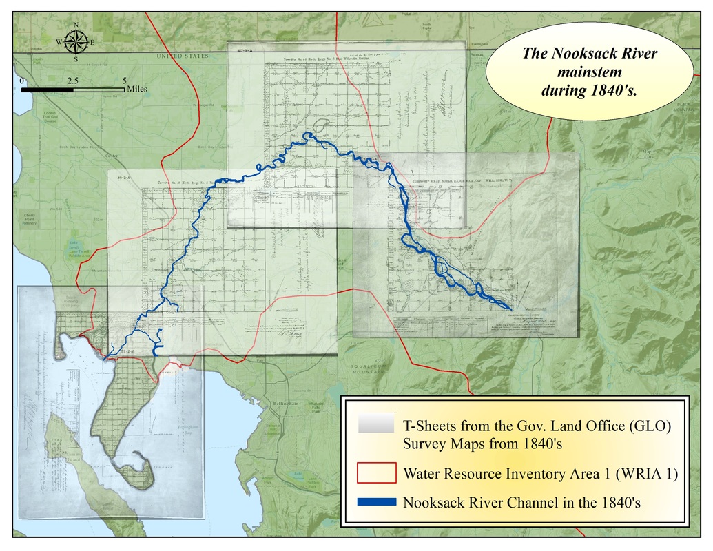
Fig 1. The Government Land Service Office (GLO) survey maps from 1800’s geo-referenced to a map of Whatcom Count. It was with this map that I digitized the old channel of the Nooksack River.

Fig 2. is an Arc Globe image of Whatcom County with the GLO maps, the digitized river channel and the Land Use Types that intersect the buffer zone.

Fig 3. This is the 8000’ buffer zone\riparian zone with the intersect tool output showing the Whatcom County Zones symbolized in different colors.

Fig 4. a graph of my output data set: total area in acres, per zone, affected by the re-established riparian zone.

Fig 5. A chart of the estimated high and low cost of the re-establishment proposal.

Fig 6. The modern Nooksack River running through agricultural land of Whatcom County.

Fig 7. A healthy riparian zone next to Ag. land.

Fig 8. The American River Riparian Zone as it appears running through the metropolis of Sacramento, California.
